
Tornado Warning Spurs Quick Action in Wisconsin as Multiple EF-1 Tornadoes Confirmed
In southern Wisconsin, severe weather conditions have recently led to the confirmed touchdown of multiple tornadoes. National Weather Service (NWS) teams have been surveying the impacted areas to assess the extent of the damage and the intensity of these tornadic events. As of now, four tornadoes have been confirmed, with additional assessments ongoing.
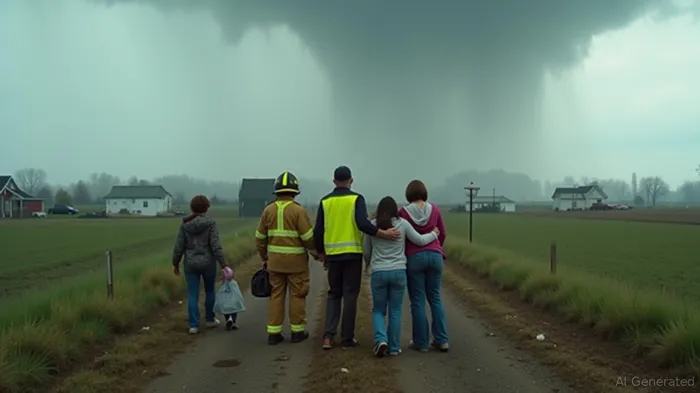
On Wednesday, a significant weather system swept through southern Wisconsin, prompting meteorologists to issue warnings as they tracked the storms in real time. Blaise Keller, a meteorologist for WISC-TV in Madison, was broadcasting live when he noticed a dangerous weather pattern forming. This system was approaching his mother's neighborhood. Keller managed a brief on-air pause to contact his mother, who confirmed they were in the basement watching the weather report, a decision that likely ensured their safety. Post-storm assessments revealed that an EF-1 tornado had grazed the area, causing considerable tree damage but leaving the family's home and livestock unharmed.
The NWS has confirmed a specific timeline for these occurrences. The initial tornado, classified as an EF-1, struck near Dodgeville in Iowa County with estimated winds reaching 95 mph, affecting areas close to major road intersections. Another EF-0 tornado was reported in Dane County, specifically near Mazomanie, achieving maximum wind speeds of 80 mph and resulting in tree and roofing damage.
In Dodge County, a brief EF-0 tornado was observed near Beaver Dam, as well as another EF-0 event southwest of Hustisford, with winds recorded at 70 mph. Both occurrences contributed to local agricultural damage, predominantly affecting cornfields and nearby tree lines.
While these tornadoes mainly impacted rural areas, the extent of structural damage remains under investigation. Preliminary reports suggest minimal residential damage, though barn and outbuilding structures experienced varying degrees of destruction. The swift response and precautionary measures advocated by meteorologists likely helped mitigate injury risks.
Further investigation is ongoing in other affected regions, including video analyses and community reports, which may result in the identification of additional tornadoes. The NWS continues to update its information as weather specialists complete their surveys.
Residents in the affected regions are commended for their attention to warnings, which played a crucial role in safeguarding lives during these severe weather events. Community efforts continue as cleanup and recovery processes are underway. As these analyses unfold, the collective vigilance and swift disaster response will be instrumental in ensuring future preparedness against nature’s unpredictable forces.
Stay ahead of the market.
Get curated U.S. market news, insights and key dates delivered to your inbox.


Comments
No comments yet