
Tornado Warning Prompts Power Outages and Damage in Greater Grand Forks Area Storm
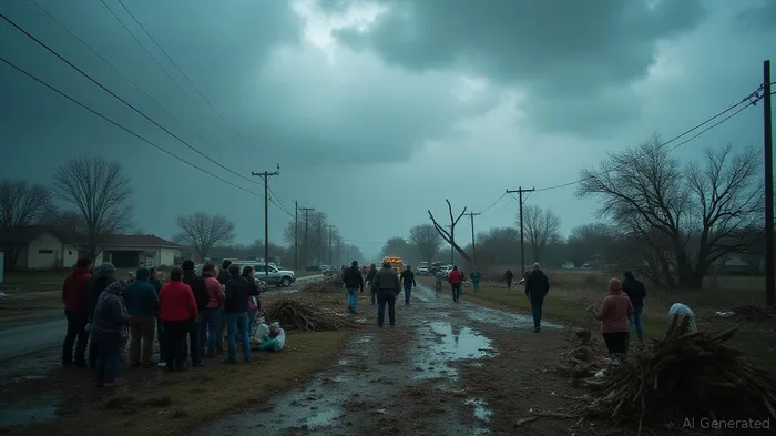
In the early hours of Friday morning, severe weather swept through the Greater Grand Forks area, possibly marked by tornado activity at the Grand Forks Air Force Base. The event prompted tornado warning sirens to sound at 4:20 a.m., following a tornado warning issued at 4:12 a.m. The storm wreaked havoc across the region, with wind speeds reaching upward of 90 mph west of Grand Forks, resulting in significant damage, particularly to the Thompson grain elevator, and causing power outages in Grand Forks.
Meteorologist Amanda Lee from the National Weather Service reported wind speeds of 50 to 60 mph throughout the Red River Valley, with the peak winds measured at 91 mph at Grand Forks Air Force Base. Field teams were dispatched Friday morning to verify the exact nature of the storm’s impact, assessing whether any tornadoes touched down during the event. While radar circulation hinted at a tornado, visible damage was also attributable to notably strong winds. Although no tornado sightings were confirmed, the elevated wind speeds at the Air Force base suggest the possibility of a brief tornado touchdown.
The storm's trajectory spanned North Dakota, stretching from the Canadian border to South Dakota, affecting several other locations with varying degrees of severity. Southwest of Grand Forks in Logan Center Township, winds reached 67 mph, while Emerado recorded 74 mph. In Minnesota, Alvarado saw winds hitting 75 mph, yet Roseau experienced relatively minimal impact with winds at 25 mph. Rainfall varied, with Grand Forks accumulating around three-quarters of an inch by 8 a.m., after some initial measurement discrepancies due to startup conditions earlier in the day.
As the storm system moved eastward, analysts predicted further development of weather patterns, extending into Minnesota, influenced by the atmospheric instability prevailing in the region. The National Weather Service has advised residents to stay informed via their social media channels for further updates.
In Steele County, North Dakota, another limb of the storm dealt substantial damage, particularly in Sharon, where grain bins were toppled, roofs damaged, and power lines downed, leaving the community without electricity. Finley also suffered from the storm’s force, with grain bins causing vehicle damage and municipal structures hit hard. Efforts to restore power commenced swiftly, though some areas, like Sharon, awaited estimates for restoration completion. The Steele County Sheriff's Office urged residents to bypass storm-damaged areas for safety and to facilitate clean-up operations.
As residents faced disrupted daily routines due to weather conditions, the National Weather Service warned of continued storms potentially carrying heavy rains and tornado threats into the weekend. Thousands remain under advisory for possible severe thunderstorms, prompting authorities to emphasize preparedness and vigilance amidst shifting atmospheric conditions.
Stay ahead of the market.
Get curated U.S. market news, insights and key dates delivered to your inbox.


AInvest
PRO
AInvest
PRO
Comments
No comments yet