
Flash Flooding New Jersey: State of Emergency Declared Amid Severe Storms and Travel Disruptions
An extensive storm system is sweeping across the Northeast United States, prompting a state of emergency across all 21 counties in New Jersey as severe weather unleashes heavy rainfall, flash floods, and potentially damaging wind gusts. The order, enacted by Acting Governor Tahesha Way, addresses the imminent threat posed by severe thunderstorms bearing down on the region. Rainfall predictions suggest 1 to 3 inches may blanket the state, with some areas vulnerable to torrential downpours reaching up to 7 inches. Flash flood alerts remain active, with warnings extending until the evening hours.
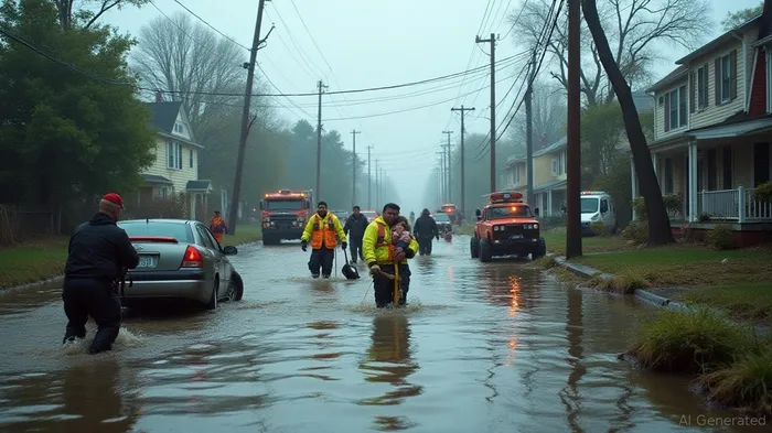
New Jersey residents are urged to exercise caution by staying off the roads and minimizing outdoor activities as storms pose risks such as landslides, rockslides, and flooded roadways. Way's executive order implements early closure of state offices, including the Motor Vehicle Commission, allowing resources to be efficiently deployed to counteract the adverse weather conditions. Additionally, Newark Liberty International Airport experienced a ground stop affecting travel, underscoring the travel disruptions faced by commuters and travelers alike.
The storm's impact resonates across wider regions, including the New York City metropolitan area, which anticipates similar disruptions. The vulnerabilities of the area's infrastructure are exposed as the NYC transit system grapples with potential service interruptions from the forecasted rainfall rates. Indicators suggest subway stations may experience flooding due to the downpour—rainfall rates are expected to soar beyond typical operational thresholds, heightening commuter difficulties during peak hours.
Mayor Eric Adams declared a localized state of emergency for New York City, advising individuals to remain informed and act with caution as excessive rainfall threatens to cause flash floods. Gov. Kathy Hochul echoed these concerns with a statewide emergency declaration, mobilizing state agencies to respond to heavy downpours and localized flooding while monitoring conditions to prioritize the safety of residents.
Reports from Northern Boulevard, Queens depict a dramatic scene as the Clearview Expressway floods, stranding vehicles and necessitating rescue operations by the New York Fire Department. Extreme rainfall saw vehicles submerged and drivers waiting on top of their cars for aid. Despite this, first responders successfully rescued all occupants without reported injuries, and the roadway has since reopened.
In Pennsylvania, heavy rain resulted in flash floods in Reading and instigated precautionary measures across southeast Pennsylvania, New Jersey, and Delaware to brace for severe weather, including potential tornado threats. With Friday promising relief, conditions post-storm are expected to provide lower humidity and cooler temperatures, ushering in more serene weather for the weekend.
Flight operations across major airports including Newark Liberty, JFK, and LaGuardia face significant delays due to thunderstorms, complicating air travel schedules. Travelers are advised to remain updated with airlines for the latest status on flights.
As emergency declarations scale from New Jersey to New York, and stretching further afield, forecasts anticipate weighty, challenging conditions as thunderstorms persist overnight. Analysts predict rainfall between 4 to 6 inches, compounded by severe thunderstorm warnings across several states. Residents are reminded to exercise vigilance, heed safety protocols, and await further advisories as the situation evolves.
Stay ahead of the market.
Get curated U.S. market news, insights and key dates delivered to your inbox.


Comments
No comments yet