
NISAR Satellite Launch Revolutionizes Earth Observation with US-India Collaboration
A groundbreaking satellite mission between the United States and India, commencing a new era of Earth observation, has been successfully launched to detect small changes on Earth's surface that are often indiscernible. The NASA-ISRO Synthetic Aperture Radar mission, known as NISAR, represents the first collaborative satellite project between NASA and the Indian Space Research Organization (ISRO). This satellite, equipped with dual-frequency radar systems, is engineered to provide detailed, high-resolution data, enabling unprecedented scientific exploration and disaster management capabilities.
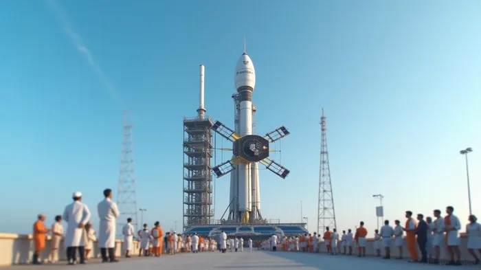
Lift-off occurred at the Satish Dhawan Space Centre on India's southeastern seaboard, utilizing the ISRO Geosynchronous Satellite Launch Vehicle Mk II. The satellite employs two synthetic aperture radar systems, an L-band provided by NASA and an S-band provided by ISRO, collaborating to achieve scientific insights that neither could accomplish independently. By orbiting Earth 14 times daily, NISAR will enable the scanning of almost all of Earth's ice and land surfaces, delivering measurements precise enough to detect changes as minute as fractions of an inch.
NISAR's mission is devised to capture a comprehensive range of data regarding natural and human-caused phenomena. Its advanced radar capabilities will aid in the understanding of landslides, earthquakes, forest structure, and more. This publicly accessible data will be instrumental in advancing preparedness for and responses to hurricanes, volcanic eruptions, flooding, and wildfires, enhancing the global capacity to combat these challenges.
A testament to international cooperation, NISAR's journey commenced with discussions following the US National Academy of Sciences' 2007 decadal survey. These conversations led to a partnership agreement between NASA and ISRO on September 30, 2014. Each agency played crucial roles: ISRO provided the S-band radar, the satellite body, launch vehicle, and services, while NASA contributed the L-band radar, a radar reflector antenna, and various critical components of the spacecraft.
The satellite features radar instruments specially calibrated for different Earth surface sizes, allowing it to measure phenomena ranging from individual leaf sizes and surface roughness to large boulders and tree trunks. The radar systems can capture motion, deformation, and moisture content details by emitting microwave signals that can pierce through clouds and rain at any time of day. This ability allows NISAR to potentially detect precursors to natural disasters and assist in analyzing infrastructure risks.
The mission has not only advanced scientific knowledge but also strengthened the collaboration between the US and India. The development saw engineers from both nations working across 13 time zones, requiring extensive coordination and travel. Wendy Edelstein, Deputy Project Manager at JPL, has traversed to India numerous times, fostering deep collaboration with ISRO colleagues, illustrating the enriched partnership founded on shared objectives.
India's Minister for Science and Technology, Dr. Jitendra Singh, emphasized that NISAR embodies a scientific handshake between India and the world, underscoring the country's diplomatic role in global scientific cooperation. This sentiment is echoed in the mission's potential to deliver critical data globally, benefiting sectors such as disaster management, agriculture, and climate monitoring.
The mission marks a notable milestone in India's growing space endeavors, aligning with ambitions like launching Gaganyaan, the country's inaugural human spaceflight, and setting up a space station in forthcoming decades. NISAR, with its duality of radar operations from a single satellite, represents an innovative leap forward, offering three-dimensional mapping to inform scientific, agricultural, and policy-making efforts globally.
Overall, NISAR's multifaceted data will propel Earth studies, augment disaster intervention proficiency, and solidify international scientific alliances, making it a pioneering endeavor in Earth science.


Comentarios
Aún no hay comentarios