
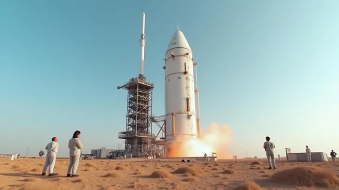
NISAR Launch Revolutionizes Earth Observation with Advanced Radar Technology
The NISAR satellite, developed through a collaboration between NASA and the Indian Space Research Organization (ISRO), aims to transform our understanding of Earth's surface dynamics. The NASA-ISRO Synthetic Aperture Radar satellite will provide high-resolution imagery of Earth's surface, using dual-frequency radar technology to observe and map land, ice, and oceanic regions. NISAR will orbit Earth 14 times a day, scanning nearly all the planet’s land and ice surfaces twice every 12 days, thus offering unprecedented data valuable for scientific research and practical applications worldwide.
Following its successful launch, NISAR will operate in a Sun-synchronous orbit for at least three years, with NASA and ISRO jointly managing the satellite. This mission exemplifies international collaboration, advancing Earth observation capabilities through the most sophisticated radar system ever utilized in a NASA or ISRO mission. The radar system includes an L-band payload from NASA and an S-band payload from ISRO, designed to capture minute changes in Earth's surface features down to fractions of an inch, making it unparalleled in precision and scope.
Aimed at enhancing preparedness for natural hazards, NISAR will provide critical insights into events such as earthquakes, volcanic eruptions, landslides, and floods. Its ability to penetrate clouds and rain will aid urgent-response communities during weather disasters, offering data vital for decision-making and timely interventions. The mission will help monitor infrastructure, land deformation, ecosystems, and human-induced changes, supporting a wide range of applications in agriculture, disaster management, and environmental conservation.
Among its key objectives, NISAR will study ice sheet dynamics in Greenland and Antarctica, track changes in soil moisture affecting vegetation, and contribute to an improved understanding of deforestation impacts on the carbon cycle. Collaboration between NASA and ISRO marks a significant step in Indo-U.S. space cooperation, leveraging shared expertise to develop technologies with global benefits.
The satellite's design is a marvel, featuring a dual-radar system with a common unfurlable reflector antenna mounted on a deployable boom over 9 meters long. This technological feat allows it to synchronize radar data in time and location, enhancing its sensitivity across a variety of surface conditions. By integrating both L-band and S-band radars on a single platform, NISAR offers a more comprehensive monitoring capability than prior missions. It scans a wide swath of 242 kilometers and provides data with resolutions ranging from 5 to 100 meters.
A defining characteristic of the NISAR mission is its free and open data policy, offering broad access to information within days of observation or in near-real-time during emergencies. This democratization of data supports a wide array of applications and contributes significantly to global scientific research and policy formulation, particularly benefiting regions that may lack access to similar technologies.
NISAR's impending data collection phase will commence following the deployment and calibration of its systems, expected to be completed by the end of October. This mission is set to produce a substantial daily volume of data, furthering research into climate resilience and ecosystem monitoring. Scientists and policymakers anticipate that NISAR's insights will be instrumental in advancing sustainable development goals and responding effectively to environmental and climatic challenges.
As it embarks on its historic mission, NISAR stands as a testament to the collaborative potential between spacefaring nations. It reflects ISRO's evolving role in global satellite technology and NASA's ongoing commitment to fostering international partnerships for science and humanity's collective good. By tracking Earth's dynamic surface changes, NISAR promises to enhance our understanding and management of natural and human-made phenomena, safeguarding communities and ecosystems for future generations.


Comentarios
Aún no hay comentarios